Projects & Sales History

23711 132 Avenue, Maple Ridge — Rezoning, Subdivision & Development History

Original 2016 records document Brookside Properties Ltd. and Jim Isherwood’s direct role in land ownership, development applications, consultant coordination, subdivision planning and the resulting property strategy—and keep that work separate from the townhomes later built by others.

Project at a Glance

Original property

23711 132 Avenue, Maple Ridge, BC

Owner and developer

Brookside Properties Ltd.; Jim Isherwood was an owner/director

2016-175-RZ

3 Lot Residential Subdivision; Brookside Properties identified as developer and applicant

2016-176-RZ

16 Unit Townhouse Development; Brookside Properties identified as developer in the civil engineering package

Townhouse parcel

Lot 4, Plan EPP73927; marketed and sold by Brookside Properties in 2018, later addressed as 23710 133 Avenue

Original documentation

Land title, application signage, civil plans, consultant reports, covenant and archived MLS record

The original 23711 132 Avenue property and the later townhouse parcel at 23710 133 Avenue are not the same address. Original 2016 records identify Brookside Properties as developer for work at 23711 132 Avenue; this record keeps that direct role separate from the approvals and construction later undertaken by other parties on the resulting townhouse parcel.

The Original Property Story

Evidence: owner-provided first-party project history

Brookside Properties Ltd. owned the original property at 23711 132 Avenue, and Jim Isherwood was an owner/director of the company. A 2017 Land Title search identifies Brookside Properties as the registered fee-simple owner of original Lot 23, Plan 48925. In 2016, the company was directly involved as developer and applicant—not merely as a real estate brokerage—in the rezoning, development-application, consultant-coordination and subdivision work for the property.

City File 2016-175-RZ concerned a 3 Lot Residential Subdivision. A separate civil engineering package for City File 2016-176-RZ concerned a 16 Unit Townhouse Development. These related files document distinct components of the original development work rather than a single outside-developer marketing assignment.

Plan EPP73927 formalized the resulting parcels. Brookside marketed and sold Lot 4, the townhouse development parcel, in 2018. Two residential lots at the front were created and sold to a builder. Brookside retained the original post-and-beam home on its own parcel, gutted and completely renovated it, and later sold it.

Brookside’s documented role was original land ownership, rezoning, subdivision, component creation, disposition and renovation—not construction of the eventual 16 townhomes.

Original Development Documentation

Evidence: original 2016 development-application sign

2016-175-RZ — 3 Lot Residential Subdivision

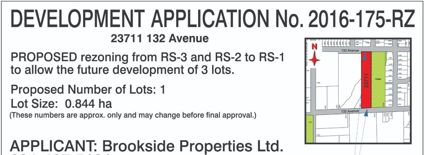
The surviving application sign identifies Brookside Properties Ltd. as applicant, Jim Isherwood as contact, and 23711 132 Avenue as the subject property. It describes proposed rezoning from RS-3 and RS-2 to RS-1 to allow future development of three lots. The related civil engineering plans identify Brookside Properties as developer of the “3 Lot Residential Subdivision.”

2016 sign proof for Development Application No. 2016-175-RZ at 23711 132 Avenue, Maple Ridge, naming Brookside Properties Ltd. as applicant and proposing rezoning from RS-3 and RS-2 to RS-1 to allow future development of 3 lots
Privacy-safe excerpt of the sign proof (Revision 1, dated June 2, 2016) for Development Application No. 2016-175-RZ. It identifies Brookside Properties Ltd. as applicant; the crop excludes historic contact details. Figures shown on the sign were noted as approximate and subject to change before final approval.

Evidence: original 2016 civil engineering plans

2016-176-RZ — 16 Unit Townhouse Development

A separate civil engineering package identifies Brookside Properties as developer of the “16 Unit Townhouse Development” at 23711 132 Avenue. This is direct documentary evidence of Brookside Properties’ development role at the application and planning stage. It does not mean Brookside constructed the eventual townhomes: the townhouse portion was subsequently subdivided and sold, and later records concern the resulting parcel at 23710 133 Avenue under other parties.

Evidence: 2017 Land Title search and registered covenant

Ownership and stormwater obligations

A 2017 Land Title search identifies Brookside Properties Ltd. as the registered owner in fee simple of original Lot 23, Section 28, Township 12, NWD Plan 48925, PID 006-352-855. The ownership application was received September 15, 2016, and the record shows a declared value of $1.2 million. That historical field is not presented as a current valuation or a sale price.

A Section 219 stormwater covenant dated August 1, 2017 names Brookside Properties Ltd. as Covenantor and the City of Maple Ridge as the City. It documents the company’s obligations to construct and install onsite stormwater works addressed by Centras Engineering’s November 30, 2016 report, with engineering inspection and professional assurance. Banking, mortgage and private contact information are intentionally omitted.

Brookside Properties Ltd. is the development entity identified in these original records. Royal LePage Brookside Realty is a distinct brokerage and is not described here as the developer.

2018 Disposition of the Townhouse Development Site

Evidence: archived MLS R2261928

The closed 2018 MLS record identifies Brookside Properties Ltd. Inc. No. BC 1073743 as owner of the resulting townhouse parcel at 23710 133 Avenue: Lot 4, Section 28, Township 12, New Westminster District, Plan EPP73927, PID 030-395-178. The approximately 2.00-acre Silver Valley site was listed by Royal LePage Brookside Realty on April 25, 2018 for $3,200,000. The record shows seller acceptance on May 9 and subject removal/completion on June 28, 2018.

The remarks presented Lot 4 as an opportunity to build 16 townhouses and stated that substantial investigation and reports had been completed. Proposed designs were described as approximately 1,309–1,419 square feet, with double garages, open living areas and rear yards. These are historical proposal details, not descriptions of the homes later completed by subsequent parties.

The same record offered separate purchase opportunities for two single-family lots and the existing renovated single-family home. That independently corroborates the first-party account of the three-part outcome: a townhouse development parcel, two house lots, and the retained and renovated original home.

Brookside Properties carried the land through ownership, investigation, development applications, consultant work, subdivision and the 2018 disposition of Lot 4. Royal LePage Brookside Realty was the listing brokerage. Later townhouse approvals and construction belong to subsequent parties.

Environmental and Geotechnical Review

Evidence: original 2016 consultant reports

Letts Environmental Consultants’ January 13, 2016 Environmental and Natural Features Assessment describes an approximately 0.845-hectare (about 2.1-acre) site containing Maple Ridge Park Creek, Cedar Park and conservation areas, steep slopes and a significant rocky outcrop. It called for a 15-metre environmental setback from the top of bank of Maple Ridge Park Creek and concluded that development was achievable provided its recommendations and applicable setbacks were followed.

The assessment was addressed to Royal LePage Realty – Brookside Realty c/o Jim Isherwood and states that Jim retained Letts for the work. That correspondence documents Jim’s consultant coordination; it does not replace the civil-plan and application records identifying Brookside Properties Ltd. as developer/applicant.

GeoPacific’s March 24, 2016 geotechnical investigation found the proposed residential development feasible from a geotechnical standpoint provided its recommendations were incorporated. For the initial layout it recommended a minimum two-metre geotechnical setback from the top of the creek bank while expressly noting that additional environmental and municipal setbacks could apply.

The two-metre geotechnical recommendation is not the environmental setback. The environmental assessment identified a separate 15-metre setback from the creek’s top of bank.

Two Addresses, Two Stages of the History

Evidence: first-party history and MLS-derived record

23711 132 Avenue

This is the original-property address and, after subdivision, the retained home parcel. The 2019 MLS-derived record identifies the home as Lot 3, Plan EPP73927, Section 28, Township 12, NWD.

Evidence: City of Maple Ridge record

23710 133 Avenue

This is the later townhouse parcel: Lot 4, Plan EPP73927, Section 28, Township 12, NWD, PID 030-395-178. Archived MLS R2261928 documents Brookside Properties’ 2018 disposition; City files 2016-176-RZ and 2016-176-DP concern the 16-unit townhouse proposal at this separate address.

Development and Parcel Timeline

  1. January 13, 2016 · Original consultant report

    Environmental and natural-features assessment

    Letts Environmental Consultants documented approximately 0.845 hectares of land, Maple Ridge Park Creek, Cedar Park and conservation areas, steep slopes and a significant rocky outcrop. The report was addressed to Royal LePage Realty – Brookside Realty c/o Jim Isherwood and records that Jim retained Letts for the assessment.

  2. March 24, 2016 · Original geotechnical report

    Geotechnical investigation

    GeoPacific found the proposed residential development feasible from a geotechnical standpoint provided its recommendations were incorporated. Its initial-layout recommendation used a minimum two-metre geotechnical setback from the top of the creek bank and noted that additional environmental and municipal setbacks could apply.

  3. 2016 · Original application sign and civil plans

    Two related but distinct development applications

    Original civil engineering records identify Brookside Properties as developer for the 3 Lot Residential Subdivision under 2016-175-RZ and, in a separate package, for the 16 Unit Townhouse Development under 2016-176-RZ. The surviving 2016-175-RZ application sign identifies Brookside Properties Ltd. as applicant and Jim Isherwood as contact.

  4. September 15, 2016 · 2017 Land Title search

    Registered ownership record

    A 2017 Land Title search records an ownership application received on this date and identifies Brookside Properties Ltd. as the registered fee-simple owner of the original Lot 23, Plan 48925. The title record shows a declared value of $1.2 million; that figure is reported as a historical land-title field, not a present valuation.

  5. August 1, 2017 · Registered Section 219 covenant

    Stormwater covenant and development obligations

    A registered Section 219 covenant names Brookside Properties Ltd. as Covenantor and the City of Maple Ridge as the City. It records obligations for onsite stormwater works based on Centras Engineering’s November 30, 2016 report, including construction, engineering inspection and professional assurance.

  6. April–June 2018 · Archived 2018 MLS record

    Brookside disposition of the townhouse development site

    Archived MLS R2261928 identifies Brookside Properties Ltd. as owner of the resulting Lot 4 townhouse parcel at 23710 133 Avenue. Royal LePage Brookside Realty listed the approximately two-acre site on April 25, 2018 for $3,200,000; the closed record shows seller acceptance on May 9 and subject removal/completion on June 28. It marketed the parcel as an opportunity for 16 townhouses after substantial investigation and reports.

  7. 2018 · City of Maple Ridge public record

    Later townhouse rezoning record

    The City public-hearing record for file 2016-176-RZ describes an application to rezone the later 23710 133 Avenue parcel from RS-3 to RM-1 for 16 townhouse units.

  8. February 2019 · City of Maple Ridge Council report

    Independent townhouse proposal

    The City report for files 2016-176-RZ and 2016-176-DP describes 16 units in four buildings, access from 133 Avenue, double-car garages, a common activity area and retaining walls. It names Hillside Ventures Ltd. as the applicant and records Advisory Design Panel review on May 16, 2018.

  9. 2019 · MLS-derived property history

    Retained home renovated and sold

    MLS-derived history records the extensively renovated original home at 23711 132 Avenue as listed and sold in 2019, with two neighbouring residential lots also offered separately.

  10. Completed in 2023 · Later City and public project records

    Later townhouse development completed by subsequent parties

    The 23710 133 Avenue parcel later became the completed 16-home Hillside Homes development. Current City material identifies the completed project, while public project records identify Azure Group as its developer.

What the Later City Record Establishes

Evidence: City of Maple Ridge public records

The City’s 2018 public-hearing record for 2016-176-RZ describes rezoning the 23710 133 Avenue parcel from RS-3 to RM-1 to permit 16 townhouse units. The related development-permit file is 2016-176-DP.

The February 12, 2019 City Council report describes 16 units in four buildings, access from 133 Avenue, double-car garages, a common activity area, retaining walls and the proposed RM-1 zoning. It identifies Hillside Ventures Ltd. as the applicant at that later stage and records Advisory Design Panel review on May 16, 2018.

That applicant record supports the chronology that the townhouse parcel had moved to another party. Hillside Ventures Ltd. is not presented as Brookside Properties, and its later application work is not attributed to Brookside or Jim.

The Retained Post-and-Beam Home

Evidence: first-party history corroborated by MLS-derived property history

Brookside retained the original post-and-beam home at 23711 132 Avenue, completed an extensive interior renovation, and sold it in 2019. The historical listing described a five-bedroom, three-bathroom, 2,741-square-foot home on approximately 0.4 acres and stated that the renovation used approved City permits.

The same listing record noted two additional neighbouring RS1B lots available separately. Together with the retained home’s Lot 3 legal description and the City’s Lot 4 legal description for the townhouse parcel, these records corroborate the subdivision outcome without assuming undocumented lot addresses or details.

Subsequent History of the Townhouse Parcel

Evidence: later City and public project records

The separate 23710 133 Avenue parcel ultimately became Hillside Homes, also referred to as Hillsides. Current City economic-development material identifies the 16-townhome project as complete in 2023; public project records identify Azure Group as the developer.

This completion is subsequent parcel history. Brookside Properties did not construct Hillside Homes, and Jim Isherwood is not presented as the developer of Azure Group’s completed project.

Brookside & Jim Isherwood’s Development Connection

The original documents substantiate hands-on Maple Ridge and Silver Valley development experience: property ownership; development and rezoning applications; coordination of civil, environmental and geotechnical consultants; subdivision planning around creek, conservation, slope and rock constraints; creation and disposition of separate development components; and renovation of the retained home.

Review Brookside’s broader projects and sales history, development and commercial guidance, or Jim Isherwood’s background.

Evidence Boundaries

The Land Title search, original application and civil records, consultant reports, registered covenant and archived MLS record document Brookside Properties Ltd. and Jim Isherwood’s direct ownership, development, consultant-coordination and disposition roles. Owner-provided history establishes the renovation and component strategy. City records establish the later application history and later applicant. MLS-derived history corroborates both the 2018 Lot 4 disposition and the retained home with neighbouring lots. Each source is used only for the facts it supports.

This record does not infer an acquisition date from the title-application date, state a rezoning approval date, ownership percentages, profit, unverified lot addresses, or the names of the townhouse-site buyer or residential-lot builder. It reports only the documented 2017 declared value and 2018 MLS list price and dates; no mortgage, banking, commission or historic contact details are published. The application-sign excerpt is the only approved documentary image currently used.

Silver Valley & Maple Ridge Context

The property history sits within the wider Silver Valley development story. For current neighbourhood and property information, explore the Silver Valley area guide and live listings or Maple Ridge new-construction guide.